Showing posts with label Riau. Show all posts

Kuntan Singingi District is not only famous for its cultural attractions such as the Pacu Jalur but also its natural attractions. As Nature Tourism waterfall, now the priority is Guruh Gemurai Waterfalls. Local Government of Kuntan Singingi has been fix this tourist attraction. Availability of a paved road so easily accessible, the parking area, an open stage to organize events, such as music and other concerts, small mosques also have been available in Guruh Gemurai Waterfall.

Guruh Gemurai Waterfall located in the District of Kuantan Mudik (Lubuk Jambi), precisely in the Kasang Village. You can reach it by private vehicles or public transport. The distance from the Taluk Kuantan capital of Kuantan singingi about 25 kilometer to the Kiliran Jao (the border of West Sumatra-Riau). You will pass Lubuk Jambi Traditional Market, and found two forked road, choose the left that uphill road, this area is called the village of Koto (Kote Ate), past the little winding road, five minutes drive you will get to the Kasang Village, and get on your trip in 10 minutes again, then you will meet with the gate to the right of the street that reads “Selamat Datang di Objek Wisata Air Terjun Guruh Gemurai” (Welcome to Tourism Object Guruh Gemurai Waterfall).

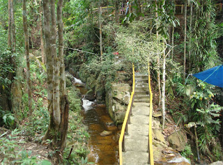
Until now, tariffs went into these attractions in accordance with declaring been regulated by the Department of Revenue Kuantan Singingi Regency, which is IDR 1000 for two-wheeled vehicles, IDR 1.500 for four-wheeled vehicles, IDR 3000 for adults and IDR 1000 for the children .

Guruh Gemurai is a name derived from the local language. Guruh is the sound of water roaring from waterfall. While Gemurai is the sound of splashing water scattered. So construed Guruh Gemurai is a thunderous waterfall and have a spark.

On weekends and holidays, Tourism Object Guruh Gemurai Waterfall crowded and become a mainstay of Tourism Object in Kuantan Singingi District.

Location :
Guruh Gemurai Waterfall located in the District of Kuantan Mudik (Lubuk Jambi), precisely in the Kasang Village. You can reach it by private vehicles or public transport. The distance from the Taluk Kuantan capital of Kuantan singingi about 25 kilometer to the Kiliran Jao (the border of West Sumatra-Riau). You will pass Lubuk Jambi Traditional Market, and found two forked road, choose the left that uphill road, this area is called the village of Koto (Kote Ate), past the little winding road, five minutes drive you will get to the Kasang Village, and get on your trip in 10 minutes again, then you will meet with the gate to the right of the street that reads “Selamat Datang di Objek Wisata Air Terjun Guruh Gemurai” (Welcome to Tourism Object Guruh Gemurai Waterfall).


Bukit Tigapuluh National Park (also called Bukit Tiga Puluh and Bukit Tigapulah) - The Thirty Hills - is a 143,223 hectare National Park in eastern Sumatra, consisting primarily of tropical lowland forest, largely in Riau province, with a smaller part of 33,000 ha in Jambi province. It is famous as one of the last refuges of endangered species such as the Sumatran Orangutan, Sumatran tiger, Sumatran elephant, Sumatran rhinoceros and Asian tapir, as well as many endangered bird species. It forms part of the Tesso Nilo Complex biodiversity hotspot. The Park is inhabited by the indigenous peoples of the Orang Rimba and Talang Mamak tribes.

Ecosystem types within the Park include lowland and highland forests, with flora such as Gutta-percha, Shorea, Alstonia scholaris, Dyera costulata, Koompassia excelsa, Rafflesia hasseltii, Daemonorops draco and various kinds of rattan.

According to a 1994 survey Bukit Tigapuluh National Park has 59 species of mammal, 6 species of primate, 198 species of bird, 18 species of bat and various species of butterfly. Mammals include Sumatran Orangutan, Sumatran tiger, Sumatran elephant, Sumatran rhinoceros, Asian tapir, Sun bear, Siamang, Crab-eating Macaque, Sumatran Surili, Sunda Loris, Clouded Leopard, Leopard Cat, Marbled Cat, Malayan Civet, Indian Muntjac, Sumatran Serow and Java Mouse-deer.

Bird species include: Great Argus, Little Green-pigeon, White-rumped Shama, White-bellied Woodpecker, Crested Serpent-eagle, Hill Myna, Helmeted Hornbill, Wrinkled Hornbill, White-winged Wood Duck, Storm's Stork, Garnet Pitta and Grey-breasted Babbler.

The Park also has an important role in protecting the hydrology of the Kuantan Indragiri watershed.

In 1982 the National Conservation Plan highlighted the importance of Bukit Tigapuluh ecosystem and classified the two conservation areas of Bukit Besar Wildlife Sanctuary (200,000 ha) and Seberida Nature Reserve (120,000 ha) as priority I conservation areas. In 1992 the Indonesian Government in cooperation with the Norwegian Government conducted a research to document the biological value of the Bukit Tigapuluh ecosystem. As the result of research, the Bukit Tigapuluh ecosystem with an area of 250,000 ha was recommended to be determined as national park. In 1995 Bukit Tigapuluh was established as national park by Ministerial Decree comprising an area of 127,698 ha. In 2002 its area has been extended to 144,223 ha

The Park has been under consistent threat from illegal logging and palm oil plantations, with two thirds of the park logged. Surrounding buffer zones and wildlife corridors are diminishing, with 30,000 hectares, the largest area of forest remaining outside the Park, released in May 2009 by the Indonesian government for logging, with the licence granted to a joint venture company involving Asia Pulp & Paper/Sinar Mas Group (APP), to clear the largest area of forest outside the Park.

A. Glance

Zamrud Lake was originally a two lakes adjoining, the Big Island Lake and Lower Lake. Because in the village of Zamrud , both lakes are more popular among the people with the name of Zamrud Lake. Since November 25, 1980, lake and forest area that has a view typical of primary swamp forest is set by the government as a wildlife area. Lately citizens with local government proposes an area of ​​2500 hectares are used as a national park.

B. Feature

Zamrud Lake has a natural panorama alluring and exotic. The air is cool and clean, and away from the bustle and noise of the city population, can be used as an alternative place for visitors to unwind or simply for inspiration. The advantages of this region lies in the fusion concept Ujungkulon National Park in the province of Banten and Lake Toba to the island Samosirnya located in North Sumatra Province. In this area are found many rare species found elsewhere, such as gold arowana fish (schleropages formasus), fish Balido, Sumatran tiger (pantheratigris sumatrensis), red bear (Helarctos malayanus), as well as various types of snakes. Even the chirp of birds serindit (loriculus galgulus), who became an icon of Riau Province, can be found in this area. When you look at the Zamrud Lake from the air, the reflection of black water in the middle of swamp forest and petroleum wells drilled nearly resembles the Zamrud gem. In the afternoon, when the sun began to set, the inhabitants of this region, such as hawks, monkeys and even tigers, began to reveal themselves one by one.

C. Location

Zamrud Lake Village is located in Emerald, Indrapura Siak district, Siak regency, Riau Province, Indonesia.

D. Access

From the city of Pekanbaru, Zamrud Lake is about 180 kilometers. When traffic is not being crowded, can be reached about three hours from the city of Pekanbaru by using buses.

E. Accommodation and Facilities

Siak district government will develop the Zamrud Lake and the surrounding region as a tourist area tirta representative in Riau Mainland. The plan in the region will be built play areas for children, parks fishing and other supporting facilities. As a tourist area mainstay, Zamrud Lake will be equipped with various types of birds and will be filled with different types of freshwater fish, such as African catfish, catfish, tilapia and prawns, as contained in the Lake Maninjau, Agam regency, West Sumatra. This area will also be developed as a center for scientific research and medicine. Here also provided a tour guide (guide) that will guide visitors to recognize more details of this tourist area.


A. Glance

Limbungan lake was originally just a water dam for irrigation purposes. Since the location is surrounded by hills with beautiful natural scenery, this artificial lake developed into a tourist attraction of water for the residents Pekanbaru City and surrounding areas. This place is crowded on Sundays and other holidays.

B. feature

Beautiful natural panorama and cool air to make visitors comfortable and peaceful to be there. Metal frame like a suspension bridge located on the lake adds to the beauty of the region. Visitors can use a motor boat or canoe to paddle around the lake is surrounded by green hills, so it is suitable as a tourist destination tirta.

C. location

The lake is located in the Village Limbungan Limbungan, District Rumbai, Pekanbaru, Riau province, Indonesia.

D. access

From the city of Pekanbaru, Limbungan Lake is about 15 kilometers which is accessible by bus or motorcycle with a travel time about 25 minutes.

E. Accommodation and Facilities

Tourist area is equipped with various supporting facilities, such as restaurants, water bikes, boats, stage entertainment, a playground and lodging. The location is strategic because it is not too far from downtown and public transportation pass.


Merangin Waterfall attraction located in the village of Merangin, Bangkinang District, West Kampar regency, is a tourist attraction that has the natural beauty of waterfalls and pristine forest areas with a very distinctive flora.

This type of attraction is an adventure tour to explore the forest while enjoying the freshness and tranquility and natural beauty in and around the forest

Forest Tourism sights Rimbo Terantang in the village of Padang Lawas who has the natural beauty of native forest with a very distinctive flora. Forest Tourism Terantang Rimbo also serves as a place to study natural phenomena, especially of flora and fauna. This type of tourism is an adventure tour to explore the forest while enjoying the freshness and tranquility and natural beauty of the surrounding forest.

Rupat is an island in the Strait of Malacca, Riau province, Indonesia. It lies just off the eastern coast of Sumatra, across from Dumai city, across the Strait of Rupat (Selat Rupat). Its area is 1490 km². At a population of 30,000, the island is sparsely populated, with a population density of 20 per km².Rupat is one of thousands abandoned islands. Now the population is growing year after year. It makes them expand the area for the settlement.

There is a proposal by the Malaysian government with Chinese financial backing to build a bridge from Melaka to Rupat and Dumai, called the Malacca Strait Bridge, though Jakarta seems to prefer to build the Sunda Strait Bridge first.

Teluk Meranti is a village located in Teluk Meranti Pelalawan District, Riau Province. In geographical locations in meranti bay Bantar Kampar river right at the mouth of the river Kampar.

Kampar River are located in two administrative districts in Riau Province and the Kampar regency Pelalawan. For in the Kampar River Pelalawan save an amazing natural phenomenon which ordinary people meyebutnya with "Bono"

Bono Bono or wave it is a living legend to the people who live along the Kampar River estuary, especially in the Kampar River. Because of this bono waves can produce large waves are very deadly. According to the stories of people first, waves bono can form 7 (seven) large waves that are very scary. When it's in Dutch colonial times, access to transportation they often disrupted because of this wave bono.

Knowing the enormity of the wave bono in this Kampar River, invites surfers to be able to surf on this wave bono. And there's only one region or regions in Indonesia that can surf the waves or the waves of the river is only in the Kampar River Pelalawan Riau. Even my level CUROL RIP organizations have brought such great surfers living legend Tom Curren surfing is to surf the waves of this bono. And it worked!! It is amazing.

Knowing about urban legends about bono, then the surfers call waves bono by the title "SEVEN GHOST" in Sumatra Island.

For those of you who want to visit and view or even surf the waves bono can meenmpuh multiple pathways. The first path with the Air Flight (Aircraft): you need to Pekanbaru (Airport Sutan Sharif Qasim II), then by using a rental car or have family and friends could be asked to delivered to the village of Teluk Meranti. Travel pekanbaru - Meranti Bay ranged 5-6 hours and will travel through the base of Kerinci (Pelalawan capital). A bit of information: real-time until the intersection Bunut (not much, about 15-30 minutes from Base Kerinci) you must take right turn to the right at the intersection Bunut. After that you came to the causeway to get to Teluk Meranti bono.

Or when you need information about transportation access to the Teluk Meranti, we (River Defender) is ready to help give Opera-. and for those of you who want to see this wave bono speednya you have to hire people. Because if you want to see bono can not just wave at bay meranti only.
Maybe this is old information that we can share, because almost certainly the work we have managed to raise the potential of wave bono has become national and even international travel.

But the most important is the potential of this tour can be useful for the community living around the river Kampar. so also meraka will still keep the river remain stable and not contaminated. Kampar River Keep Alive! Defender river.

Forest Preserve Kerumutan also known as wild forest reservation is situated in District Kerumutan, Pelelawan District. Area of ​​Protection Forest Kerumutan reach 93.222.20 ha forest inhabited by wild flora and fauna are protected such as timber (Shorea ASP), Punak (Nypa Fruticons), Sumatran tigers, leopards, arowana fish, wild ducks and others.

As the area of ​​protected forest, Kerumutan also inhabited by a flora and fauna that currently the population is already threatened with extinction. Call it the Sumatran tiger (Ponthera Tigris Sumatransis), Leopard etc.. Location of protected forest located in the Village Kerumutan, District Kerumutan.

Entering Pangkalan Kerinci town from Langgam Village through Kampar River, we can be served by amazing and enchanting natural scenery. Especially when we are passing by spread out plantation and local community settlement along the river, and watching them doing their daily activities. As soon as we get to the Tanjung Putus Lake, we can feel the serenity of the lake or observe the surrounding area particularly the people living in Kuala Terusan Village. Then we can rest in Senang isle, which is situated in the center of Kampar River about 5 Km from Pangkalan Kerinci.


Tesso Nilo National Park was officially inaugurated on July 19th 2004, with 38.576 Hectares width. Tesso Nilo is the biggest low land forest in Sumatera, and habitat for about 3% species of mammals in the world. a single hectare of this national park consists of 360 flora, divided into 165 genus and 57 family, 107 species of birds, 23 species of mammals, 3 species of primates, 50 species of birds, 15 species of reptiles and 18 species of amphibians. this national park is one of the low land forest that serves as conversation and habitat for about 60 – 80 elephants. visitors can explore the forest while sitting on elephant, or joining the flying squad patrol. visitors who want to experience adrenaline raising may directly herd wild elephants back to their habitat. also there are many sumateran tiger`s tracks or other animals` tracks, such as tapirs, bears, bobcats, etc.

Pelalawan village as a center of Pelalawan Kingdom has a lot of historical tourism objects which can be visited by tourists, they are Sayap Palace, King’s Grave and several heritages of Pelalawan Kingdom. Tourists can see the Sayap Palace which has got four of Soko Pillar which mean that in governing the Kingdom, king were assisted by four ministers. Besides the uniqueness of Sayap Palace, they can also see the heritages of kingdom either in or out of palace, they are like sword, keris (long blade), Arca Batu Betapa (ascetic stone statue), Lance, Sultan`s Clothes, the big & small King’s ancient Canon.


BEACH New Straits is the second most beautiful beach in Bengkalis after Rupat North Coast. The name of the New Straits Beach itself is taken from the name of the village where the beach is located, the New Straits Village, which also became Bantan Capital District.

Bengkalis government has made the beach as one of the flagship attractions. Evidently, in the region held a beach party every year. At the event held various competitions, such as boat races jong, tops, and kites. Visitors can also witness a variety of traditional arts and cultural attractions the local area.

New Strait coast has gently sloping stretch of coast and smooth sand along the 2 mile with a distance of about 200 meters from the beach. Ocean waves at this beach is relatively stable, not more than 1 meter, except at the north wind season.

From this place of Mount Ledang blue refracted in the neighboring country, Malaysia. That said, the mountain that Hang Tuah and Hang Jebat fight. While enjoying the wind and ocean waves ripple from the Straits of Malacca, the presence of sea eagles that prey on fly while fishing near the coast, became the scene of interest to visitors.

New Straits Coast Located in the Village of New Straits, District Bantan, Bengkalis regency, Riau Province, Indonesia. The beach is located in northern New Straits Capital Bengkalis. Located approximately seven miles with the distance of approximately one hour using a two-wheeled vehicle or four wheel.

From Pekanbaru, visitors can use to navigate the water transportation to the port of Bengkalis Siak River. Mileage is approximately five hours. Other access that can be used by visitors is a landline. Namely, take a bus from Pekanbaru to Siak through traffic lane east of Sumatra. Mileage is more or less two hours. From the port of Siak, then proceed with a fast boat to the port of Bengkalis with the distance of about two hours.

In this place visitors can perform various activities, such as sunbathing (sun burning) on ​​the beach, surfing (surf), boating (boating), swimming (swimming), and fishing (fishing). Except that, in the region were also equipped with international standard ports are just waiting for the time of operation and ships crossing the ferry (RO-RO) towards Pakning River, which connects with the Riau Mainland and other cities in Sumatra. The plan Bengkalis Government will also build airports making it easier for visitors to come there.


Batu Mandi island is administratively located in Rokan Hilir, Riau and becomes the outer island in Indonesia that directly bordered with Malaka Strait, Malaysia.

Pulau Batu Mandi is part of a cluster of Arwah islands or Spirit Island comprising ninesmall islands. The island is a black stone that is not too high and there is a guard office at the top. The conditions of Batumandi Island is also typical of refreshing, clean and it has normal wave. This is because the wind is blowing from the West, which no barrier to this island.

Batu Mandi island, Jemur Island and some other islands around is having a magnificent sightseeing and naturally virgin, like white sandy beach and clear blue sky. This island is also becomes the home of reserve and turtle breeding.


Jemur Island or Pulau Jemur is an island of Indonesia which is located in the Strait of Malacca, about 45 miles from capital of Rokan Hilir regency, Bagansiapiapi, and about 45 miles from Malaysia. This island is administratively part of Pasir Limau Kapas sub-district, Rokan Hilir regency,Riau province.

Jemur islands are uninhabited and only a stopover place for fishermen who are to sea. A post of Indonesian Navy (TNI-AL) was established in this island for the purposes of observation and navigation. Currently, there is no accommodation in this island. There is no regular transportation to the island. However, one can rent a speedboat from Bagansiapiapi (takes about 1.5–2 hours) or Panipahan (takes about 1 hour).

As a virgin island, Pulau Jemur has a good natural sea view and beautiful panorama, and serves as the home for sea turtles. It has a strategic location on the Strait of Malacca; during the Second World War, the Japanese built a defence on here. There are many places can be found here, such as Japanese Cave, Light House tower, and others. Moreover, Pulau Jemur is also has a natural golden sand beaches, and the local government are trying to develop it as a resort area.
Enchantment Island beach Rupat is the name given to the North Island people Rupat Rupat Island Coast which extends in the North Rupat and dealing directly with the Malaysian border. This beach was formerly have different names according to the naming of the citizens of each village that Lapin Cape Coast, Cape Coast Beach Tanjung Rhu and Punak.

The island itself has a wide Rupat 1524.84 km2, which is actually a combination of four islands that seemed to coalesce into an island. Consists of two districts namely Rupat District and Northern District Rupat. Subdistrict Rupat Rupat were in the south island and has 10 villages, namely, Makeruh, Stone Long, Long Forest, Base Nyirih, Pergam, Sei Cingam, Sukarjo Mesim, Cape Ships, Terkul, and the Gulf of glutinous.

Northern Subdistrict Rupat as the name suggests, are north of the island Rupat and has 5 villages namely Kadur, Medang Cape, Cape Punak, Rhu Bay, and Titi Roots. Both these districts have different potentials. Northern Subdistrict Rupat have tourism potential of water with a beautiful sand beach. The beach is called Island of Enchantment Rupat North Coast which is the object Bengkalis coastal tourism development.
Rupat Island beach

This beach extends from east to west and come face to face with the Cape of Deer in Port Dickson - Malaysia. Coastal areas that have a group of mineral soil to the level of youth development, either with or without the characteristic features hidromorfik hidromorfik. North Coast could see the ships passing the national and international, it is supported sea state has a depth of 10-30 meters.

When admin RiauMagazine visit to the Gulf Coast Village Charm of Rhu Island North Rupat November 2011 ago, is still quite difficult, especially transportation from the Port of Tanjung Medang Rupat island towards the village of Rhu Bay as one of the tourist sites in the coastal charm. The lack of public transport tersediaan eventually covered by a society that provides two-wheeler motorcycle taxi at the cost of mutual bargaining.

Rupat own transportation to the island is already fluent with the availability speedboat, RoRo ships, or ships pompong from some other ports to Rupat. From Port of TPI Dumai available to the Port of Tanjung speedboat Medang Rupat with cost Rp.110.000 takes about 2.5 hours. Then there is also a RoRo ship to the port of Tanjung Dumai Rupat Ship in the South who can continue the journey overland to the Gulf Coast in the Village Charm of Rhu. Another route is to use a speedboat from Bengkalis to the port of Tanjung Medang and pompong ship that will dock at Kadoor (Kadur).

All efforts to reach the location of the Island Coast which has been named Coast Rupat this Enchantment was treated with natural beauty. Sand beach that extends 12 miles and fairly flat is very fun to play ball or other games. Enchantment beach conditions are similar to conditions in the east of Bali Sanur Beach with sand flat. If weather conditions are good at night, it would seem light-light in Port Dickson Malaysia.


Pulau Tebingtinggi or literally means high cliff island, is an island in Riau province, which is geographically located at latitude (0.9 degrees) 0° 54′ 0″ North of the Equator and longitude (102.75 degrees) 102° 45′ 0″ East of the Prime Meridian on the Map of the world.

The locations related to Pulau Tebingtinggi are represented by the nearest distances for a beam of light to travel and may not be nearest by road. For example, Pulau Tebingtinggi, is located 11.7 kilometre from Selatpandjang, 11.7 kilometre from Selat Pandjang, 14.8 kilometre from Kampoengdjepoen, 14.8 kilometre from Kampungdjepun and 16.8 kilometre from Lentoek, Indonesia.

Tebingtinggi Island is an area of lowland peat land so that the need of clear water is very difficult to get. The main source of water is coming from rainwater.


Merbau is an Island and a district in the Meranti Islands regency, Riau, Indonesia. The city district is Renak Rungun.
Meranti Islands Regency is a result of the expansion area Merbau District, formed on January 26, 2011. Where the Pulau Merbau District is covering the entire island of Pulau Merbau, while Merbau subdictrict covers the entire island of Padang.

The island has bordered with Malaka strait in north, west Tebing Tinggi sub district in south, Merbau sub district in west, west Rangsang in east.